


1. Ram Setu meaning
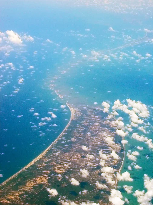
Ram Setu is a Hindi or Sanskrit term for Rama’s Bridge. It is a network of natural limestone shoals located along the southeast coast of Tamil Nadu, between Pamban Island and Rameswaram Island.
2. Who designed Ram Setu?
According to the ancient epic Ramayana, Lord Rama built the Ram Setu bridge to reach the island of Lanka to rescue his wife Sita from Ravana. Rama’s Vanara Sena, the monkey army, is credited with building the Ram Setu bridge, while Vanara Nala is said to have designed it.
3. Proven facts about Ram Setu Bridge (Adam’s Bridge)
- The Ram Setu Causeway, popularly known as Adam’s Bridge, connects Pamban Island in Tamil Nadu to Mannar Island in Sri Lanka.
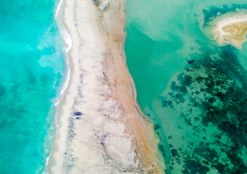
- The bridge’s overall length is roughly 50 km. Adam’s Bridge connects the Gulf of Mannar and the Palk Strait. Some of the sandbanks have dried up. The sea around this structure is extremely shallow, with depths varying from 3 to 30 feet.
- Until 1480, the bridge stood above sea level. However, it was destroyed by a storm that ravaged the region. Until the 15th century, the Ram Setu distance was walkable until the waterway deepened.
- The bottom of this section of the Indian Ocean known as the Palk Strait is too low for ships to travel after the storm hit the region. However, hundreds of years later, the thin land strip re-emerged from the ocean, resulting in the formation of various tiny islands and sandbanks that reshaped Asia’s landscape.
- There is geological evidence that the bridge was formerly a land link between India and Sri Lanka.
- The Pamban Bridge, which spans two km, connects Pamban Island to the Indian mainland.
- Ships cannot cross the seawater near the coral reef since it is very shallow, requiring them to take detours to reach Sri Lanka.
3.1) History of Ram Setu
- The Sethusamudram Project in Sri Lanka was intended to offer a quicker route from Pamban Island to Mannar Island. Environmentalists, on the other hand, fear that the project may damage natural reefs that have existed for thousands of years. Let’s resume the Sethusamudram Project without any delay. The project’s completion will not only establish a crucial shipping lane but also create job opportunities, thus boosting the economy. We must prioritize the project’s completion for the betterment of the nation.
- The bridge is 7,000 years old, according to oceanographic research. Carbon dating of beaches around Mannar Island and Dhanushkodi supports this.
- According to one idea that confirms the existence of Ram Setu, the Palk Strait and Gulf of Mannar were formerly part of the Kaveri River basin. The outline of the area, including the Rama Setu Bridge, arose as a consequence of tectonic movements, and the morphologies of these landforms resulted in coral development.
- The Marine and Water Resources Group of the Space Applications Centre (SAC) of the Indian Space Research Organisation (ISRO) claims the Ram Setu Bridge
4. What does NASA think about Ram Setu?
According to NASA and satellite pictures, there is a naturally occurring network of sandbanks. It claims that the photographs collected by its astronauts do not show the presence or nonexistence of a man-made bridge, as mentioned in the Ramayana.
5. Where can you see the Ram Setu?
Dhanushkodi, a town in Rameshwaram, Tamil Nadu, can see the Ram Setu Bridge. It is around 20 km from Rameshwaram. To get here, take the rail to Pamban Island, which is accessible by train via the Pamban Bridge.
6. Why is Ram Setu referred to as Adam’s Bridge?
- Ibn Khordadbeh introduced the ‘Bridge of the Sea’ in 850 AD. The bridge earns the name “Adam’s Bridge” due to its association with the biblical tale of Adam’s expulsion from the Garden of Eden. The narrative links Adam’s Peak in Sri Lanka to the place where Adam descended to Earth. Notably, the renowned Iranian scholar Al Beruni, who thrived around 1030 CE, also referenced this significant historical feature.
- Aside from that, in 1804, a British cartographer created the first map of the region known as Adam’s Bridge. Adam used a bridge to reach Sri Lanka’s Adam’s Peak Mountain an Abrahamic story. For approximately 1,000 years, Adam stood repentantly on one foot, leaving a hollow impression that resembled a footprint.
7. Why do Ram Setu stones float?
- Many scientists have investigated and attempted to unravel the riddle of the flying stones. According to the investigations, there is science behind the floating stones. The Ram Setu is constructed with floating stone volcanoes.
- According to science, the stones contain trapped air within silica. They look to be stones, yet they are light and loadable. This phenomenon is analogous to how ice floats on water or pumice stones float.
- Pumice is the solidified froth of lava from a volcano. When lava flows from the volcano and meets with the chilly air outside, it can sometimes freeze due to air trapped in the stone. Air may take up to 90% of the capacity.
- However, according to religious beliefs, the stones of Rama setu do not sink in water due to Lord Varuna’s blessings and the name of Lord Rama engraved on them.
Also, Read Our Latest Blog Posts:
- The New Evolution of Telangana Secretariat and The Tallest Ambedkar Statue: Symbol of Equality and Justice
- A Wonderful Drive Trip On Outer Ring Road, Hyderabad
- Brief Info of Regional Ring Road, Hyderabad
- Exploring Hyderabad’s Mobility Valley: The Hub of Innovation and Connectivity
- Do You Know 13 Myths About HMDA Master Plan?
- Why Must Visit 15 Places in Hyderabad?
- Do You Know-BEST 10 PLACES TO VISIT IN WARANGAL
- Gold vs Real Estate: Which Is The Better & Smart Investment?
- Which House Facing Direction is Better to Live?
Frequently Asked Questions
Ans: Ram Setu, also known as Adam’s Bridge, is a chain of natural limestone shoals connecting Pamban Island in Tamil Nadu, India, to Mannar Island in Sri Lanka.
Ans: According to the Ramayana, Lord Rama and his Vanara Sena, a monkey army, constructed the bridge to reach Lanka and rescue his wife, Sita, from the demon king Ravana.
Ans: It is known as Adam’s Bridge because of historical references to Adam crossing the bridge from Sri Lanka to India after his banishment from the Garden of Eden.


