

Are You Want to Know More Information on the HMDA land use zones? Then, you must read this blog post. Let’s get into detail about the latest blog post – A Full Guide to 12 Land Use Zones in HMDA Master Plan 2031.
ZONES FOR LAND USE IN THE HMDA MASTER PLAN 2031
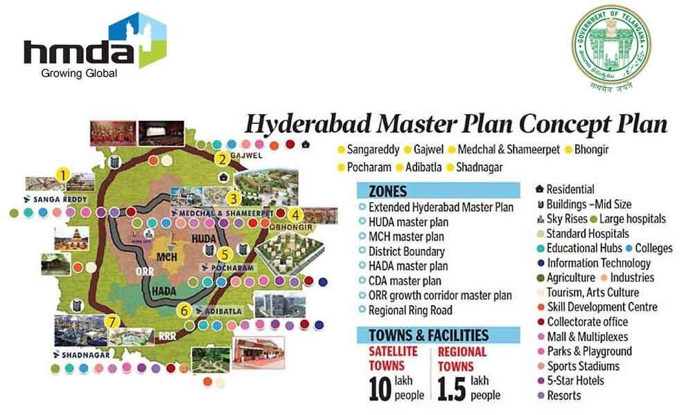
The HMDA Master Plan 2031 divides land use zones into 12 zones. Let us know about the zoning methods in-depth.
HMDA LANDUSE ZONING
The government divides the land into sections known as zones as an urban planning technique. Zoning can incorporate a number of complementary activities. Residential, commercial, agricultural, industrial, or hotel/hospitality are a few examples of zoning classifications, among other more particular purposes. Whatever their use, the various restrictions may dictate the density, size, and shape of permitted buildings.
T Zoning can establish a number of unconditional and constrained uses for the land.
The HMDA Landuse Zoning Act enables local governments to control the utilization of specific properties or plots of land within their jurisdiction for particular purposes.
The Master Plan 2031 includes a total of 12 land use zones introduced by HMDA. THEY’RE:
- Residential Use Zones (R1, R2, R3, and R4)
- Peri-Urban Use Zone
- Commercial Use Zone
- Manufacturing Use Zone
- Multiple Use Zone
- Use Zone for Public, Semi-Public Facilities, and Utilities
- Forest Zone
- Water Bodies Zone
- Agriculture Use Zone
- Traffic and Transportation Use Zone
- Recreation and Open Space Use Zone
- Special Reservations Zone
LAND USE ZONING CLASSIFICATIONS
1. Residential Use Zone
Residential zones categorize as R-1, R-2, R-3, and R-4 zones as areas with residential neighborhoods, where enterprises may or may not operate.
This zone’s goal is to maintain the neighborhood’s residential feel without allowing for businesses or more intense multifamily usage.
There are 4 different categories in a residential zone. They’re:
- R1 – Residential Use Zone
- R2 – Residential Use Zone
- R3 – Residential Use Zone
- R4 – Residential Use Zone
Let’s learn more about these Zones in depth.
2. Peri-Urban Zone
- Building usage is allowed on 25% of the land in the Peri-urban zone.
- The authorities permit residential buildings to have a maximum height of 15 meters, and commercial constructions can reach up to 18 meters. Based on construction, specific conditions will apply.
3. Commercial Use Zone
All commercial activities are permissible in this area.
4. Manufacturing Use Zone
This zone is categorized into 2 types:
i) MANUFACTURING ZONE
The only industrial developments allowed on this land. Residential building is not permitted.
ii) WORK CENTERS
The Hyderabad Airport Development Authority (HADA) created it in accordance with the master plan.
5. Public and Semi-Public Use Zone
Recognizing that public and semi-public buildings and institutions have their own distinct set of conditions as well as the important services they give to the community is the goal of the public and semi-public zone.
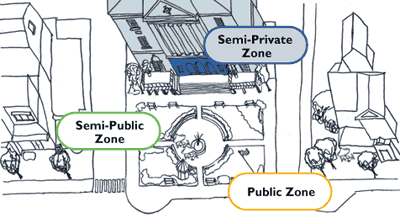
The 3 categories of this zone are as follows:
- Use zone for public, semi-public, and utilities
- Amenities
- Facilities for Public Utilities
6. Multiple Use Zone
The Outer Ring Road is close by. All constructions permitted in residential zones are also allowed here.
It is divided into 4 groups:
- Zone of Multiple Uses
- Special Development Zone
- General Development Promotion Zone (GDPZ)
- Central Square
7. Recreation and Open Space Zone
This land is only used for recreational activities. This could include everything from playgrounds, swimming pools, and sporting fields, to open places like parks.
It is divided into 3 groups:
- Zone for Recreational Use
- Open Space Buffer(Around the Foreshore of Waterbodies)
- Zone for Reforestation at Himayath Sagar.
8. Water Bodies
Generally speaking, all water bodies, including rivers, streams, lakes, tanks, and kuntas, make up the majority of the water body zone. This area includes all rivers and lakes, including Himayat Sagar.
9. Forest Zone
In forest zones, only plants and other vegetation can be grown. Authorities do not permit other actions in forest zones.
10. Special Reservations Zone
Historic Structures and Precincts, Defence Lands, and other areas make up this zone.
It is divided into 4 groups:
- Heritage Buildings and Precincts (S1)
- Defense / Military Lands (S2)
- Bio Conservation Zone (S3)
- Others (S4)
11. Conservation (Agriculture)
The conservation (agriculture) use zone is the peri-urban use zone. Crops and cattle are grown and harvested on agricultural land. This could be anything, including farms, ranches, or pastures.
12. Traffic and Transportation
Transport services are what the traffic and transport zone is all about—helping people go from one place to another.
It is divided into 4 categories:
- Roads
- Railways / Railway Stations
- Bus Depots, Passenger / Freight Terminals
- Airports
Conclusion:
The HMDA Master Plan 2031’s land use zoning provides a well-thought-out framework for sustainable urban development. By balancing residential, commercial, industrial, recreational, and environmental needs, the plan aims to create a vibrant and harmonious cityscape that caters to the present and future requirements of its residents. Proper implementation of these zoning methods will play a crucial role in shaping a well-organized and livable city in the years to come.
Also, Read Our Latest Blog Posts:
- The New Evolution of Telangana Secretariat and The Tallest Ambedkar Statue: Symbol of Equality and Justice
- A Wonderful Drive Trip On Outer Ring Road, Hyderabad
- Brief Info of Regional Ring Road, Hyderabad
- Exploring Hyderabad’s Mobility Valley: The Hub of Innovation and Connectivity
- Do You Know 13 Myths About HMDA Master Plan?
- Properties In Hyderabad
- Agriculture Land Near Hyderabad
- Villas Near Hyderabad
Frequently Asked Questions
Ans: HMDA Master Plan 2031 is an urban planning framework that divides land use in the Hyderabad region into 12 zones to guide sustainable development.
Ans: 12 Land use zones are in HMDA Limits.
Ans: The Peri-Urban Zone allows building usage on 25% of the land and has height restrictions for residential and commercial buildings.
Ans: It includes areas for public and semi-public buildings and institutions providing essential services to the community.
